| General Details |
|---|
| Course & Certification:
ID: 6.1.6 Description: Master 40GT/20m™ (SV) Certification type: Certificate of Competency ISO 9001:2015 compliance course & certification. |
| Course Length:
A total of 98 hours consisting of; Pre-Course study = 5 hours. |
| Capacity of certification:
1. Skipper of a sailing yacht up to 20.0 metres Length-Water-Line (LWL) +10% = 22.0 metres Length-Over-All (LOA). 2. Offshore waters <120Nm from a safe haven OR an offshore voyage of <240Nm distance between two safe havens. 3. Night passages coastal & offshore. 4. Tidal area with an average tidal height of less than 6 metres. |
| Endorsement Options:
Race Skipper Catamarans Ocean 20/40 Classic Sailing Vessels |
| Recognitions & approvals:
Pending, in process. |
| Reference Standards:
Syllabus & Assessments adhere to UNECE Resolution N° 40 International Certificate for Operators of Pleasure Craft, Sailing Vessels.. |
| Certification Revalidation:
Yes required, every 5 years from date of issue. |
| Sea-time requirements:
Sea Areas Category III & IV: OR: Sea Areas Category I & II: |
|
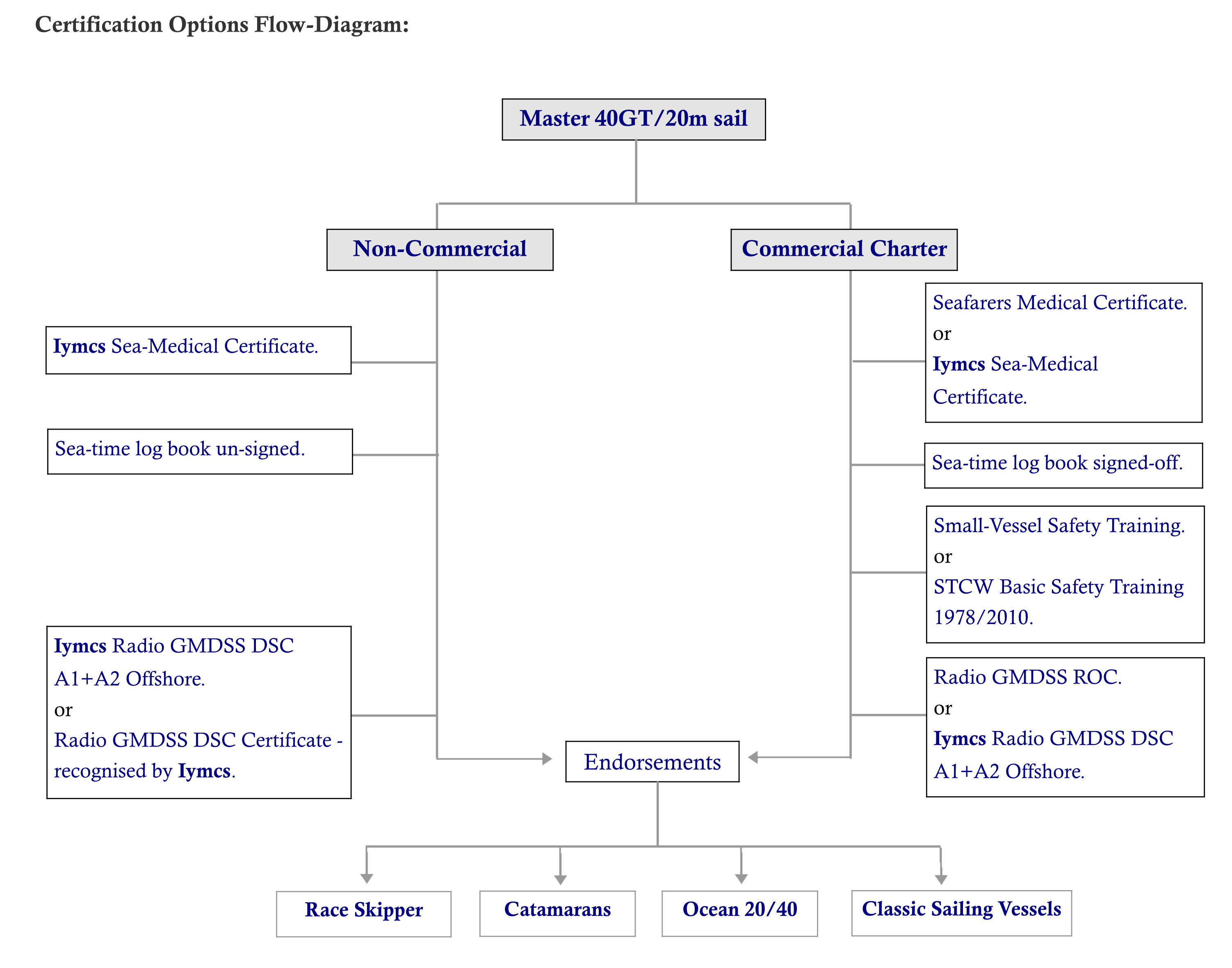
Certification issuing requirements -Non-Commercial:
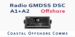
1a. Seafarers Medical Certificate 2a. Iymcs Radio GMDSS DSC A1+A2 Offshore Certificate 3a. Seafarers Medical Certificate 4. Radio GMDSS Restricted Operators Certificate 5. Sea-time log book signed-off 6. Small-Vessel Safety Training |
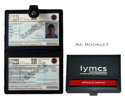
The custom-designed Iymcs booklet type certification is stylish and practical.
The booklet outer is made of real leather with a sythentic interior that is resistant to water and protects the certificates.
It is A6 in size, ideal to be kept in a crew document case or with the boat's documents in the chart-table.
The Iymcs Certificates are printed to ISO9001:2015 standards, are dual-language and feature extensive security features
to security level 3 (Government passports & national Iidentification documents are security levels 1 & 2) and can be used as a personal ID in daily situations.
(Nb. It cannot be used instead of a passport/national identity card).
The Iymcs Master 40GT/20m™ sail is a unique course and certification that has the capacity to cross-over from a non-commercial status to a commercial status in such a way that it respects the STCW 1978/2010 convention. There are no other CoC's for yachts that do this except possibly for a national Certification issued by a few Maritime Authorities. If this commercial option is chosen, it will allow crew of sailing yachts of under 40GT/20mtrs to work as a Captain in near-coastal waters subject to the approval by; the owner, the insurance company, the flag of the vessel and the regional Coastguard.
The cross-over from non-commercial to commercial can be done at any time, this is ideal for yacht owners that may consider to do owner-operator charters themselves as a Captain. For "professional sailing crew" (as opposed to "professional yacht crew" which is a different category), the Iymcs Master 40GT/20m™ sail CoC is ideal for them if they are working on an informal basis such as; looking after the owners boat, racing as boat chief or race skipper, undertaking the occassional near-coastal deliveries/transfers, sea-trials and acting as a skipper for the owner.
There some other smart features of this course.
The CoC has numerous endoresements that change the capacity of it, they include an all-ocean capacity, ideal for crew undertaking occasional delivery work.
The written and practical examinations are straight forward non-academic and all is required that the student or candidate is able to speak English at a reasonable communinication level.
The sea-time records are made-up a simple format with a basic supporting justification.
This course is a good foundation for the upper level professional courses such as the Iymcs Master 200GT/OOW 350GT™
The diagram below shows the commercial and non-commercial qualfiying aspects of this CoC.
The unique format of the Iymcs Master 40GT/20m™ sail is progressive and allows you to develop your skill set at your own learning pace. Within the extensive syllabus, you can choose several course subjects that you wish to focus upon. Another unique feature of the course is the up-to-date learning techniques that begin with the use of technologies to understand subjects and techniques, these are then underpinned by the practise of traditional methods and values as the course progresses. This approach is avant-garde and is very effective in getting to the point of what you need to know, as well as which skills are needed, to safely navigate. On-board training in elementary Radar is included that covers thr basic operations, there is a maritime law module which covers the essesntial fundamentals required in near-coastal waters.
As with all the Iymcs courses, safety is a key element but Iymcs takes the subject a stage further. To understand safety, an important criteria is situation awareness. The Iymcs Master 40GT/20m™ sail course focuses upon situation awareness skills that are vital in near-coastal waters, and deals with likely scenarios and the options on how to deal with them.
The Iymcs Master 40GT/20m™ sail course course and CoC is smart, it is proactive and has the possibility to change and develop as required. It is the bridge between the recreational world and the professional world, a competent all-rounder that opens future possibilities.
Our Society, the 'International Yacht Marine Certification Society" (Iymcs) operates its entire operations under a Quality Management System
(QMS) that is in compliance with the International Standards Organisation (ISO) 9001:2015 amended. Part of this compliance involves full auditing procedures.
This is an important reference and enables us to gain recognitions from maritime admininstrations and marine industry bodies alike.
Our Society is ISO 9001:2015 certified by the British Standards Institute (BSI) Netherlands.
The QMS together with the ISO, ensures that Iymcs and its Members operate to the highest standards possible. All our courses, and more importantly the
Certifications that we issue, are under ISO 9001:2015.
This practise is most unusual for such courses and certifications. Some organisations will claim ISO:9001 adherence but often the reality is it is for a document management
process or a similar back-office process instead of for actual operations and/or for Certification issuing.
| Scandinavia 1.600,-EUR | Northern Europe 1.400,-EUR | United Kingdom 1.100,-GBP |
| Southern Europe 1.400,-EUR | Middle East 1.400,-USD | North America 1.300,-USD |
| Prices exclude: course books,certification costs,personal travelling costs,course food and course accommodation. | ||
( Vers. 1.7. ) Click-on '+' to see Syllabus.
Types of sailing yachts. Points of the wind. Parts of a vessel. Sails and rigs. Basic nautical terminology. On-board Safety Practices.
Rules 1, 2, 3, 5, 6, 7, 9, 10, 12, 13, 14, 15, 19. Basic Sound & light signals. Basic Day shapes.
Buoyage channel layouts. IALA System A & System B. Buoyage direction. Safe-water marks. Marina port & harbour entry marks. Beach & landing stages layouts. Buoyage lights -Flashing, Occulting & Isophase. Isolated Danger marks.
Key channel marks & signals. Special vessel day & night signals. Movement control signals. Special channel signs.
Steaming lights configuration. Anchor lights. Sailing vessels -configurations. Vessel types; fishing, towing, RAM, NUC, CBD.
Raster Scan Charts (RSC’s) or Electronic Nautical Charts (ENC’s). Mercator projection & scale. Magnification of ENC charts. Int. Chart N° 1 publication. Vector Chart symbols. Intro to topography of land masses. Ports, harbours & bays. Charted depths & contour lines. Sea-beds. Obstructions.
Screen set-up; illumination, contrasts, instrument inputs, system configuration. Distance measuring -using; latitude scale, ruler, measuring tool, cursor & VRM. Measuring angles & bearings using; EBL & cursor. Understanding information boxes. Heads-up & North-up. Static mode. Information layers. Route plan.
Harbour plans. Port entry marks & lights. Buoyage system layout. Depths & obstructions. Narrow channels & near-coastal TSS. Approach crossing technique to TSS. Preparation of Pilotage plan/s
Lighthouses. Beacons, identification by day. Range/Transits, day & night. Sector lights. Deviation and Variation.
Waypoints - departure & destination. Distance off waypoints position. Distance & speed measurements. Distance-off from obstructions.
Wind speed & direction. Beaufort Scale. Sea & Land Breezes. Wave heights and velocity of. Low & high pressure, wind direction. Headland winds. Mountainous coastline wind effects. Meteo Bulletins & Forecasts. Sources of Meteo Information. How to read meteo forecasts. Restricted visibility; fog, rain & mist. Level of Confidence factors of Meteo Forecasts.
Navigation Log Book. Pilot books. Tidal Almanacs. Legal requirements to carry charts & publications. Chart and publication updates -Notice to Mariners. Plotter system ENC update requirements.
Local area large scale coastal chart. Chart publication check. Reading information. Exercises; buoyage & marks identification, depth & obstructions, major lights identification. Plotting instruments. Plotting a GPS position from plotter. Transferring waypoints from plotter. Measuring distances. Course & bearing measurement. Projected course track.
Vessel familiarization. Deck obstructions. Hand-holds on-deck & interior.
Life-jackets and Personal Flotation Devices. Safety harnesses & clip-on procedures. Life-raft procedures. Man-over-board procedure & equipment usage. Flares, types of and how & when to use them. Medical kit content. Fuel, gas & electrical cut-offs. Navigation lights. Gas detector & cut-offs. VHF Radio. Electrical Panel -DC & AC. Checking battery levels. Compartment flooding & procedure. Bilge pumps -manual & electrical. Fire extinguishers & engine compartment extinguishing system. For’ard deck and side decks.
Coiling ropes. Line throwing exercise. Use of cleats, bollards & fairleads. Use of Fenders and safety aspects. Line names. Sheets & halyards.
Fuel levels, refueling procedures. Water tank levels & re-filling. Port-holes & windows closure. Stowage check. Power shore-supply cable. Depth & Speed Log instruments. Wind instruments. Plotter. Keel bolts. Rudder.
Pre-start checks; oil, coolant and fuel levels. Check Sea-cock for cooling system. Check sea-water strainer and clean. Check alternator belt. Throttle controls - cable. Post start-up checks incl. exhaust. RPM gauge and setting speed to. Helm indicator. Cold-water start procedures.
Rudder check. Wind & waves strength & direction. Depths & obstructions. Other vessel awareness (traffic). Marina port traffic. Request entry or departure from Port Marina Office. Casting-off from the dock methods. How to enter into a port or harbour. Approaches to the dock. Organize & brief crew for docking. Singling-up lines, releasing of. Passerelle stowage.
Slow speed exercises; turning the boat in a confined area, rudder angle effect, narrow channel bends & obstructions, approaching a dock. Autopilot usage.
Organising crew tasks. Mainsail; halyard hoisting technique, use of main-sheet & main-sheet traveller co-ordination, kicking strap & boom vang, topping-lift usage. Adjustable back-stay usage. Genoa; unfurling technique, use of genoa sheet. Changing the Genoa for another. Reducing sail area; reefing or furlingmainsail, furling genoa. Genoa traveller track settings. Lowering mainsail safely.
Organizing crew tasks. Steering a course under sail. Tacking under full sail. Create a visual reference course with various tacks. Create a visual reference course to clear obstructions and shallow depth areas. Create a visual reference course to maintain a safe distance off from a headland. Moderate wind gybing (10kts-16kts). Cockpit tidiness with lines. Winch safety. Wearing harnesses & clipping-on. Awareness of leeway factors. Wind speed & direction instruments. Windex direction usage. Use of Tell-tales. Launching and take-down of Asymmetrical spinnakers in light winds (<10 kts).
Position awareness exercise using plotter with vector charts + local large paper scale chart. Identify land navigation marks and objects. Referencing position to pilot book. Distance off. Two-visual & three-bearing fix. Port or harbour entry. Depth control. Steering a course by GPS Compass and by Magnetic Compass. Calculation of TVMDC. Course through water. Pilotage plans. Use of waypoints. ETA calculations. Plot a projected course to follow to clear obstructions, shallow depths and headlands. Fuel consumption planning. Course to steers to offset leeway & tidal stream/current affects.
Boat preparation. Watch duties & allocation of. Watch-keeping briefing. Crew briefing & allocating tasks. Safety aspects and safety equipment checks. Sail and rig set-up for meteo & sea conditions. Preparation of Pilotage plan. Interior preparation. Galley preparation of light snacks and drinks. Deck & Rig checks for tacking.
Introduction to Tidal Heights. Practical explanation of Tidal Streams. Top-surface currents. The use of tidal almanacs. Chart Datum concept. Charted depths. Depth contour lines. Drying heights. Calculating time of float-off aftergrounding. Calculating clearance time to cross a harbour bar. Sea-bed characteristics. Tidal Diamonds. Tidal stream atlases.
Identify type of anchor on-board. Anchor chain/rope length, secure of. Use of Capstan. Exercise of partially lowering and raising anchor in port. Anchoring exercise in sheltered bay. Weighing anchor and departure of an anchorage. Picking up a buoy technique, securing and releasing of mooring line.
Overtaking, head-on & crossing related to the rules 13, 14 & 15. Keeping a look-out Rule 5 and maintaining a safe speed Rule 6. Rule 12 sailing vessels, port tack rule, windward rule & port leeward rule. Basic sound signals usage whilst underway. Deploying anchor signals.
Life-ring or horshoe practise throwing exercise. In-sight exercise under power; using Andersen turn, fender & bucket. In-sight exercise under sail; using fender & bucket, furl head-sail, engine used. Reach-Reach maneuver.
WC issues and dismantling of pump. Galley usage & stowage. Grab-handle points. Using of the companionway steps. Cooking a full meal underway. Provisioning list. Organizing provisioning of the boat.
Coastguard & SAR MRCC. Range of TX & RX. Power output. CH16 usage. Port channels. Distress Mayday. Safety Securite messages. Pan Medico Alert. Call-up for port entry & departure.
Engine failure. Flooding or sinking. Grounding. Fire. Towing a vessel & to be towed.
Basic heat stroke and hypothermia precautions. Sea-sickness.
Basic safety equipment check. Launching and recovery techniques. Rowing exercise - oars & paddles. Loading crew into tender. Crew sitting positions.
Passage Planning -near coastal. Creation of working Passage plans. Creation of Summary Passage Plan. Route track planning -near-coastal. Effects of tidal stream & currents. Vessel traffic density. Landfall technique for lights, beacons and land objects.
Operating principles & limitations. Screen set-up & info boxes. Radar errores. Cursor function. Range rings and their usage. VRM & EBL usage. Gain function. Sea Clutter & Rain Clutter. Heads-Up & North-Up. AIS vessels & navigation marks. Anchor watch alarm zone.